Mount Kato Ski Resort Guide
Mount Kato, United States
| Highest Lift | 165m |
|---|---|
| Resort Height | 91m |
| Nearest Airports | Minneapolis and Chippewa Valley |
| Free Snow Reports by e-Mail | Sign Up for Powder Alerts |
Mount Kato
The ski area of Mount Kato is at an altitude of 91m.
Summary
Mount Kato has direct access to a total of 8 ski lifts.
The skiing is at relatively low altitude, so snow cover can be variable.
Skiing
We do not currently have enough information to describe the skiing in Mount Kato. If you have skied here, or know the area, please tell us about it in the Ski Forum.
Snowboarding
Sorry, we don't yet know much about Snowboarding in Mount Kato.
Snow and Weather
When will it snow in Mount Kato?
There is currently no significant snow in the 7-day forecast for Mount Kato.
See our long-range Snow Forecast for the latest update, or Join our Snow Mail Here
Snow this week
| Thu | Fri | Sat | Sun | Mon | Tue | Wed |
|---|---|---|---|---|---|---|
Ski Area Stats
Mount Kato Ski Area
| Ski Lifts Number of Lifts | 8 | |
|---|---|---|
Altitudes & Slopes
Mount Kato Ski Area Heights
| Highest Lift | 165m |
|---|---|
| Lowest Piste | 91m |
| Resort Altitude (Mount Kato) | 91m |
Location and Map
Where is Mount Kato?
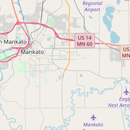
This ski resort is in Mankato, Blue Earth, United States.
Map
Tap ![]() for Full-Screen, or see J2Ski's Resort map, showing Hotels and Ski Shops.
for Full-Screen, or see J2Ski's Resort map, showing Hotels and Ski Shops.
How to get there
By Air
The nearest airport to Mount Kato is Minneapolis, 94 minutes drive away.
Chippewa Valley airport is also within three hours drive.
Infrastructure
Ski Lift Capacity
The eight ski lifts are able to uplift 14,650 skiers and snowboarders every hour.
Season Dates
When is Mount Kato open?
We don't currently have confirmed season dates, but hope to soon.
NOTE:- Ski area, lift and piste opening is subject to Current Snow Conditions.
