J2Ski Snow Report - December 29th 2022
J2Ski Snow Report - December 29th 2022
Published : 29-Dec-2022 19:48
J2Ski Snow Report 29th December 2022
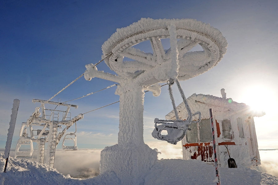
Big White, BC, Canada after a 30C temperature change...
Snow in Europe, but more in America.
The Snow Headlines - 29th December
- Snowfall at high altitudes in the Alps, but unfortunately rain at high levels too.
- Mega Storm Elliott freezes North America and brings more snowfall to many.
- High avalanche danger in the Alps as warm, windy and wet impacts snow cover.
- Bulgaria continues to struggle to open much terrain.
- More snow in Scotland.

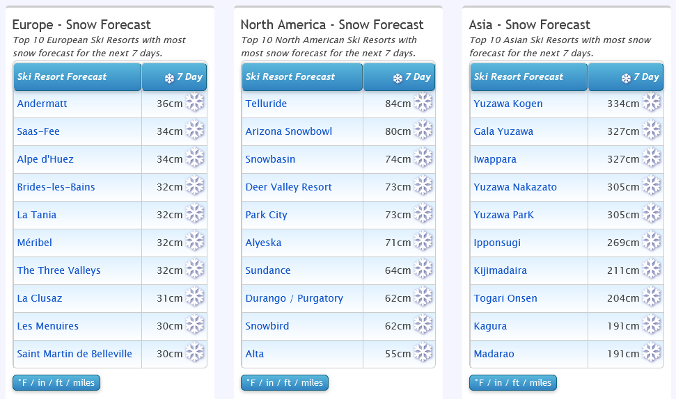
Japan's just showing off now...
Re-publication :- our Snow Report Summary, being the text above this line, is free to re-publish, but must be clearly credited to www.J2ski.com with text including "J2Ski Snow Report" linked to this page - thank you.
World Overview
The winter weather is certainly keeping us on our toes this week with lots of different extremes to report.
In Europe, unfortunately, warm temperatures continue to impact lower slopes, with rain, strong winds and mild air also leading to high avalanche danger. Above 2,000m conditions remain pretty good though, as they do up in Scandinavia. By contrast, though there's almost no snow down in Bulgaria.
North America has seen a really dynamic weather mix as has been widely reported in mainstream media with very low temperatures and some significant snowstorms. This time the East of the continent has ended up with some of the best accumulations so it is an improving picture there. More storms are now hitting the West.
Europe
Austria
A very mixed picture for Austria with altitude a key factor as to whether you'll find good skiing or not.
The northern Alps have, unfortunately, not seen much of the December snowfalls and it has also been warmer than the seasonal average in valleys. The result of this unhappy combination was a green Christmas in valleys and wet snow on higher runs for many of the Austrian areas topping out below 2000m altitudes.
On the other hand, those with runs up towards 3000m are in good shape. Solden is the real stand out with almost twice as much snow lying as almost any other Austrian resort and virtually all of its 150km of slopes open.
France
French resorts continue to post the deepest snow depths in Europe, although they've lost their dominance of the top 10 with some Swiss resorts moving in there. But Alpe d'Huez, Puy St Vincent, Tignes, Val d'Isere and Serre Chevalier all remain in the top 10 for snow depth with 1.5 – 2.1 metres lying each.
It's been a challenging week with rain up to high elevations for Christmas weekend and the thin snow cover lying on valley slopes melting/washed away in some cases, but there's also been more snow up above 2000m, so it's very mixed and there's still some good skiing up high.
The off-piste avalanche danger is high with the mild temperatures, rain and strong winds thrown into the mix.
Italy
Italy seems to have fared slightly better than some other leading ski nations during the warm weather.
Ski areas have been opening more runs and some are now fully open. The Milky Way (Via Lattea) including the skiing at Sestriere, Sauze d'Oulx and Montgenèvre over the French border is reporting the most terrain open, over 250km of slopes. The cross-border Zermatt-Cervinia region has over 200km of runs open too.
In the Dolomites, most terrain is now open with Val Gardena leading the pack with all 80 lifts running and all 180km of slopes open despite just a 1-2 foot base reported.
Switzerland
Swiss centres have the same scenario as those in the rest of the Alps – good conditions and fresh snow above 2,000m altitude at most resorts.
At lower altitudes though rain and warm temperatures have thawed the limited cover. As most Swiss resorts have plenty of high-altitude terrains the conditions aren't too big a problem. But the issue has proved difficult for some resorts to avoid. Laax, for example, despite having slopes up to 3000m, has warned of narrow stretches of snow in places.
Scandinavia
Powder skiers looking for fresh snowfall would be best to turn their eyes north (or make it easier by just clicking on the applicable webcams) as Scandinavia is the place where the snow has been falling in abundance over the last week. Some centres have reported over half a metre of fresh snowfall.
Norway has reported the heaviest snowfalls with several resorts including Geilo and Voss now posting snow depths of over a metre on their highest runs.
Pyrenees
Ski areas in the Pyrenees have been battling warm temperatures too and the amount of terrain open here has dropped a little compared to Christmas weekend.
It's the same issue as further north in the Alps – too warm and too dry when it comes to fresh snowfall. The deepest reported snowpack, on the French side, is only 70cm but Baqueira Beret and Grandvalira both still report over 100km of slopes open.
Scotland
Scotland's season is improving again after the warm weather last week. It's been back below freezing and snowing again. The Lecht, Glenshee and Cairngorm all re-opened some slopes on Boxing Day and snowfall continuing through this week led Glencoe to aim to join them on Wednesday. Alas, it was thwarted by rain late on Tuesday evening rather than the snow forecast.
Eastern Europe
Unfortunately, the warm weather in Europe's southeast continues to severely limit what ski areas can offer.
Most Bulgarian ski areas have opened now but with just a few short runs created during snowmaking windows overnight and Sarajevo's ski slopes in Bosnia remain closed.
It's a brighter picture further north where larger Czech and Slovak ski areas like Spindleruv Mlyn and Jasna have been opening more terrain despite the warmer-than-ideal temperatures here too, very much like the Alps.
North America
Canada
Western Canada's period of super-low temperatures largely eased over Christmas weekend and it got up to the mere minus 5-10s (Centigrade) in Alberta and Eastern BC.
However fresh storms arrived earlier this week, hitting coastal resorts like Whistler Blackcomb hard - which had to largely close as gale force winds hit along with rain and snow. It has largely reopened now though.
Further inland there were reports of 10-30cm of fresh snowfall after the cold but dry weather and Big White noted problems with ice build-up on lift machinery as temperatures fluctuated through 30 degrees below freezing.
Eastern Canada has seen a dramatic improvement in what had been poor early-season conditions with many areas receiving half a metre or more of fresh snowfall from Storm Elliot.
USA
The big weather story this past week was Storm Elliot which passed right across the US from west to east bringing bitterly cold weather, gale-force winds and, most markedly in the Midwest and northeast – plenty of snowfall.
In the East that transformed the previously lacklustre conditions into powder skiing. There was snowfall for the Rockies too and now a fresh series of storms, with the most optimistic forecasts pointing to another "up to eight feet" of snowfall by the start of the New Year, moving into the west.
The problem with storms though is that while the snow accumulations are great news for the long term, in the short term gales, buried roads and lifts and high avalanche danger can all cause ski areas to shut down for a day or two.
Join the conversation : Discuss this in the J2Ski Forum
This news item has been viewed 8,724 times.
Also on J2Ski :- Tignes Snow Forecast Ski Hotels Ski Hire Ski Holidays