J2Ski Snow Report - February 26th 2026
J2Ski Snow Report - February 26th 2026
Published : 26-Feb-2026 18:18
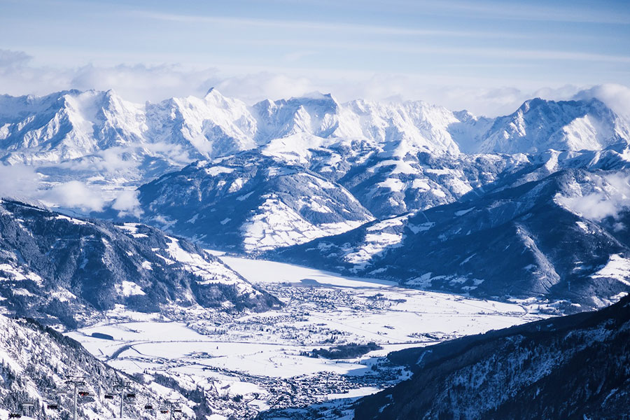
Sun and snow, from the Kitzsteinhorn, Zell-am-See, Austria
Huge snow across the western US, with up to 90 inches (2.3 m/8 feet) reported in California, while the Alps and Pyrenees have had heavy snow followed by sunnier, milder weather and persistent high avalanche risk. Scandinavia, Scotland and parts of North America remain in good shape and Canada has seen fresh powder.
The Snow Headlines - February 26th
- Snow storm totals up to 90 inches (2.3 m/8 feet) in California.
- Avalanche danger remains high as sunshine returns to much of the Alps.
- Temperatures finally start to warm up in Scotland after remarkable two cold months.
- Alpe d'Huez first in the Alps to post 4 metre/13 feet+ base this season.
- Some smaller, lower western US ski areas announce their 25-26 season is over.
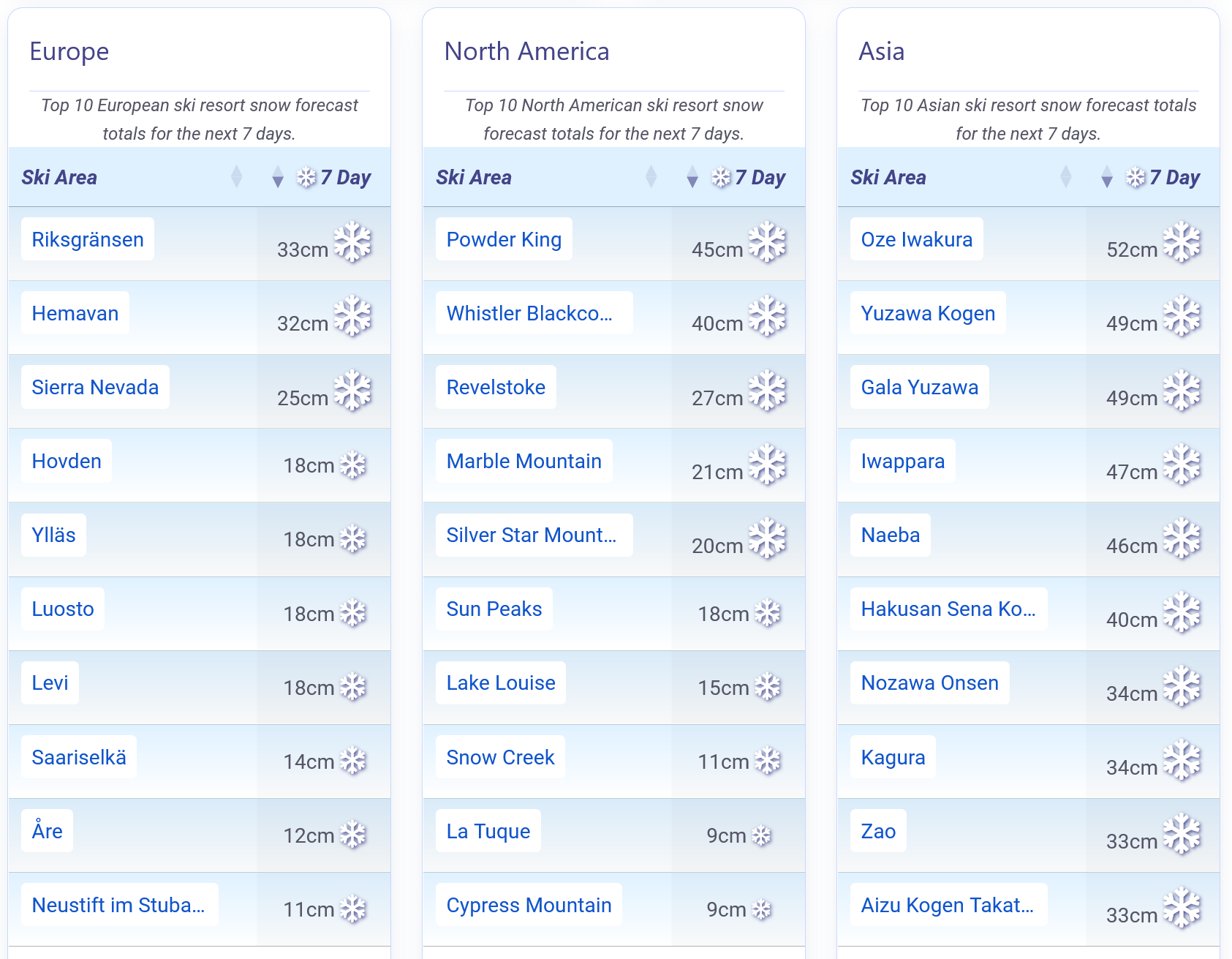
A little more Snow forecast.
Re-publication :- the J2Ski Snow Report Summary, being the text above this line, is free to re-publish, but must be clearly credited to www.J2ski.com with text including "J2Ski Snow Report" linked to this page - thank you.
World Overview
After an extraordinary run of Alpine snowfall, with some western high‑altitude areas collecting close to 3 m/10 feet in a week, conditions have eased markedly. Resorts in the west are now reporting calmer, milder, almost springlike weather since the weekend although Austria stayed snowy later into the week. Avalanche danger remains high, but more terrain is reopening as safety work continues.
A similar pattern is playing out in the Pyrenees, where sunshine has returned, while light to moderate snow has lingered across Austria and parts of eastern Europe. Scotland is enjoying one of its strongest seasons in years with further fresh snow, and Scandinavia remains cold, open and in excellent shape.
Across the Atlantic, the standout story is the major storm cycle in the western US that was happening as we published last week's report. As in the Western Alps, accumulations were huge by the weekend. The southern Rockies saw their biggest snowfall of the season, with around two feet falling in just a few days.
Further north, parts of Utah and Wyoming received significant boosts, with some resorts reporting up to five feet. California was hit hardest, echoing its late‑December storm, with upper‑mountain totals reaching 7.5 feet. The heavy snow brought short‑term disruption, including road closures, high avalanche danger and buried lifts, but skies have since cleared.
Europe
Austria
Since the snowfall ended in the western Alps at the weekend, Austria has picked up the most new snow of the major Alpine nations.
Light to moderate daily top‑ups have kept pistes refreshed, although they have also brought poor visibility at times. Despite lower totals than the western Alps in recent weeks, authorities continue to warn of high avalanche danger, particularly in Tirol and the west of the country, where levels remain at 4.
The latest snowfall has pushed the country's first base above 2 m/7 feet this season, with little Ifen in Vorarlberg now reporting the deepest cover at eight feet (2.4 m/8 feet).
It has now turned sunny in most areas and that's expected to continue into next week.
France
Nearly two weeks of heavy snowfall and stormy weather in the French Alps eased at the weekend, replaced by sunshine and notably milder temperatures. Lower valleys have climbed to around +10°C/50°F, while the freezing level has risen above 2,500 m/8,202 feet, nudging even high‑altitude readings above zero as meteorological spring approaches.
Calmer conditions have allowed resorts to reopen terrain, although avalanche risk remains considerable off piste. Chamonix's ski areas were completely closed last Friday but partially reopened on Saturday. Saturday saw an inbounds avalanche cross a piste at La Tania in the 3 Valleys.
With snowfall totals of up to 3 m/10 feet in the region over the two weeks, Alpe d'Huez is the first French resort to reach a 4 m/13 feet base this season, currently the deepest in Europe. Families arriving for the second week of the February holidays are finding far more stable weather and significantly more terrain open. The sunny weather is expected to continue into next week.
Italy
Italy's run of major February snowstorms eased over the weekend, just as the final Olympic events were being staged, giving way to a return of the mostly clear, sunny conditions that dominated much of early winter. Avalanche risk remains high across several regions, particularly in the northwest and northeast, after last week's heavy accumulations.
The Milky Way (Via Lattea) is about 90% open now, offering the country's greatest extent of open terrain, with over 320 km/200 miles of pistes. Again, the sunny weather conditions are expected to continue for the coming week.
Switzerland
Stormy weather reached right across Switzerland last week, even if the west saw the most intense snowfall.
Avalanche risk remains high across the country with St Moritz in the southeast posting over a metre/3 feet of fresh snowfall.
As with much of the Alps, after nearly two weeks of unsettled conditions, the country has enjoyed a calmer spell since the weekend, with sunshine, rising temperatures and notably mild air, particularly noticeable in lower valleys with afternoon temperatures reaching +10°C/50°F at 1,000 m/3,281 feet altitudes.
A little cooler for the coming week but the current sunshine should continue into March.
Scandinavia
Scandinavian ski areas have seen a slight rise in temperatures, though conditions remain firmly wintry with most slopes sitting between −5°C/23°F and −15°C/5°F.
Lapland still dipped into the −30s (around −30°C/−22°F) over the weekend, reminding visitors that true Arctic cold hasn't gone far.
Recent unsettled weather has delivered 15–30 cm/6–12 inches of fresh snow this week to leading resorts like Hemsedal and Trysil in Norway, helping maintain strong coverage across the region. Most resorts continue to operate with 90–100% of terrain open. Sweden's spring‑skiing centre Riksgränsen opened for its 2026 season at the weekend.
Pyrenees
After weeks of stormy, snow‑laden weather, the Pyrenees and wider Iberian region have finally enjoyed a spell of calm. Sunshine and dry conditions have taken over, and temperatures have climbed noticeably, reaching around +10°C/50°F in the valleys and edging above freezing on higher slopes. Avalanche risk off piste remains elevated.
Resorts have been steadily reopening terrain as conditions stabilise, with many now offering their highest lift and piste counts of the winter.
Andorra's Grandvalira (Pas de la Casa, Soldeu etc) leads the region, operating 99% of its runs open and more than 3 m/10 feet of snow lying.
Scotland
After two months of low temperatures and snowfall it has turned milder at last this week in the Highlands. Ski centres report they've lost some snow but that runs are mostly holding up well. It's been a windy week with sharp showers, which have been falling as rain, sleet or snow depending on altitude and time of day.
All five Highland centres remain open for snowsports although Nevis Range has been closed Monday to Wednesday, and it is currently deciding open/closed days a little in advance.
Eastern Europe
Eastern Europe has held onto solid winter conditions, even as temperatures have edged slightly higher further west. Most resorts are operating in a stable −5°C/23°F to −10°C/14°F range, with colder pockets in the high mountains.
A series of snow showers has refreshed pistes with around 10–20 cm/4–8 inches of new snowfall, supporting reliable coverage across the region.
Many ski areas continue to report 90–100% of terrain open. Bulgaria's Bansko has the most terrain open in the region.
North America
Canada
Canada has seen a welcome return of powder this week, particularly in the West, where a frigid, dry start to the year has shifted to more regular snowfall. Totals haven't been dramatic, but 10–20 cm/4–8 inches has refreshed slopes in Alberta and BC, with temperatures down to around −15°C/5°F helping preserve quality.
Revelstoke currently reports the region's deepest cover at 2.6 m/9 feet, and most resorts in the region are close to fully open. Further east, conditions remain cold and mainly dry.
USA
The powerful winter storm that was underway as we published last week's report ended up delivering major snowfall across western North America, transforming conditions from California to the Rockies. The southern Rockies saw their biggest dump of the season, with around two feet falling in just a few days. Further north, parts of Utah and Wyoming received significant boosts, with some resorts reporting up to five feet.
California was hit hardest, echoing its late‑December storm, with upper‑mountain totals reaching 7.5 feet. The heavy snow brought short‑term disruption, including road closures, high avalanche danger and buried lifts, but skies have since cleared.
It's not all good news: several small centres in Idaho have announced they've closed for the season after the new snow was deemed too little too late, especially as it's since turned milder and drier again.
It's remained wintry on the East Coast with some more big storms here and fresh powder and everything open.
Join the conversation : Discuss this in the J2Ski Forum
This news item has been viewed 299,091 times.
Also on J2Ski :- Alpe d'Huez Snow Forecast Ski Hotels Ski Hire Ski Holidays